Today's trip was from Rock Springs to Cheyenne, Wyoming, a relatively short trip as things go, and had we simply powered across Wyoming on I-80, we would have been there around 3 PM. However, our relaxed schedule allowed us to make lots of side trips to look at things that took our fancy.
I added more than fifty new photos and videos to my Flickr account today. Click through any of the photos below to see the other related photos.

Near the end of the day, we made a rail enthusiasts' pilgrimage to a large historic artifact of US railroading: the Ames Railroad Monument. This pyramid once marked the highest point on Union Pacific's original transcontinental railroad, but the UP relocated the line to an easier grade south of here, so the pyramid sits in lonely splendor on the high plains.

This historical marker at the Laramie railroad depot gives more details of the monument. It's a very impressive structure. We took many more photos than just the one above of me and Kuma Bear standing at the base of the pyramid.
Although we finished the day with a trip to look at a railroad pyramid, it took a lot of traveling to get there.

Setting forth from Rock Springs, we encountered many interesting rock formations along the line of travel as we crossed and re-crossed the continental divide several times on I-80.

There were trains. Lots of them. This looks like the priority intermodal train that usually goes past our house in Fernley every morning. It's relatively short and somewhat overpowered, and nothing is supposed to get in its way.

We stopped in Rawlins to look at the historic Rawlins Depot. Like the other passenger stations along the Union Pacific "Overland Route," there is no longer passenger service here ever since Amtrak discontinued the Pioneer/Desert Wind (successors to UP's City of Portland and City of Los Angeles).

A fence now separates the station from the railroad line.

...which is probably a good thing, as trains come speeding through regularly. It may not look it, but I'm behind the fence here, albeit standing on a block that allowed me to shoot over the fence.

A decently well-maintained former Union Pacific caboose stands on display here. The "P" means the caboose was in "pool" service, rather than being assigned to a specific train conductor as was once common practice on many railroads.
Although our emphasis was on trains, there were other things to see.

East of Rawlins we had a look at the Sinclair Oil Refinery. We didn't realize until yesterday that Sinclair and the Little America hotels were under common ownership, which explains why Little America has been a Sinclair gas station from the beginning.

Further east, we stopped at the Wagonhound Rest Area. This view is to the south. Wide open vistas and the potential for howling winds are the order of the day in these parts.

This marker explains that the rocks here were "tipi rings" used to hold down the bottoms of Native American tipis.
After Wagonhound, I suggested that we stop in Laramie and have lunch there as we did eight years ago on our trip to the Denver Worldcon, and Lisa readily agreed.

Laramie has built a park next to the historic depot. We stopped here eight years ago and had a picnic lunch. We did the same thing this afternoon, sitting at the same table. The weather was better today than it was back then, with mild temperatures and light breezes.

The historic depot is tidy, but sad. Train stations need passengers.

Eight years ago, we were treated to a parade of maintenance of way equipment during our picnic lunch. Today, just as we arrived, this general merchandise freight thundered through. Because of the placement of the station and the tracks, we get a much closer look at the trains here than we can do at Fernley.

There is equipment on display here in Laramie, but it's rather dilapidated.
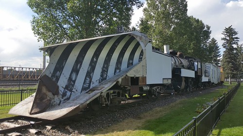
Highlight of the display is this massive snowplow once used to clear the line of the huge amounts of snow that regularly fall here in Wyoming.

The locomotive that is part of the Snow Train has seen much better days.
I suggested that we leave the Interstate for a while and follow the UP tracks a bit south and east, working off of the state highway map and our railroad timetables. Lisa agreed, and I tried to navigate us to where we wanted to go.

I was amused by this junction marker of roads leading in all directions, which is an artifact of a north-south highway (US-287) being multiplexed with an east-west highway (US-30). We took south US-287, which diverges from US-30 here after having run along each other through Medicine Bow from near Rawlins.

At a place called Tie Siding on US-287, Hermosa Road is a local dirt road that runs up to Hermosa, a point on the Union Pacific main line where the two-track main line spawns a third main line that takes an alternative route from here west to Laramie. This entire area is generally part of "Sherman Hill," the highest point on the UP mainline.

We had stopped to take a picture of the three-track grade crossing when this westbound intermodal showed up. Even with a gated grade crossing, you want to be very careful around the tracks of a railroad as busy as the UP.

Lisa was very taken by these odd rocks on the north side of Hermosa Crossing.

Storms were brewing north of us as we slowly made our way up the heavily washboarded road. My minivan is not made for off-pavement travel, so Lisa took it very slowly at times. This was just as well, because when we saw something we wanted to photograph, we could stop quickly.

We had seen pronghorn antelope (not a true antelope, but filling a similar ecological niche in North America) throughout the day but at freeway speeds, getting a picture of them was impossible. We came across this herd and I tried to get out and take a picture. However, my camera only has a 4x zoom, and the pronghorn started to leave when I tried to photograph them.

Lisa was able to get her Sony camera and telephoto lens out before the herd had retreated completely, getting this and several more good shots (again, click through to see the others).

This is the best shot I managed on my camera phone, of this lone pronghorn we encountered farther up the road.

I got a much better close-up of these two horses that appeared to be standing watch over a cattle guard. They did not seem troubled by our passage.

The reason we had come this way was because the map said the Ames Monument was along this road, and eventually it hove into view.

It's an impressive edifice.

![[livejournal.com profile]](https://www.dreamwidth.org/img/external/lj-userinfo.gif) travelswithkuma and I are dwarfed by the pyramid. The rock in front of me in this picture appears to be a leftover from construction.
travelswithkuma and I are dwarfed by the pyramid. The rock in front of me in this picture appears to be a leftover from construction.

It may not look like it, but this was once the summit of the Union Pacific mainline, at over 8000 feet above sea level. Sherman Summit ran right through here. The remains of the right of way are visible. A private road to the right is named Iron Horse Road and is on the original right-of-way. Although a great feat of engineering that inspired the building of the Ames Monument, the line was operationally difficult, and the UP relocated the tracks several miles south of here, leaving the pyramid to languish in the plains.

The stones continue to remember the Union Pacific here in Wyoming.
We had one last stop before heading to the hotel in Cheyenne.

Buford, Wyoming, claims a population of 1. (Lisa says she saw the resident inside the store, which was closed for the evening.) At 8000 feet, it is both the highest and the smallest town along the entire length of Interstate 80 from New York City to San Francisco.
Around 8 PM, with hours of sight-seeing behind us, we pulled in to the Holiday Inn Express in west Cheyenne. This hotel wasn't quite as nice as the one in Rock Springs, but the room had a bathtub, which Lisa appreciated after a long day in the saddle driving us east.
Tomorrow we start out by checking out the Cheyenne Railroad Depot, after which we plan to make the relatively short run to North Platte, Nebraska, probably taking US-30 (and following the railroad) as much as it is practical to do so.
I added more than fifty new photos and videos to my Flickr account today. Click through any of the photos below to see the other related photos.
Near the end of the day, we made a rail enthusiasts' pilgrimage to a large historic artifact of US railroading: the Ames Railroad Monument. This pyramid once marked the highest point on Union Pacific's original transcontinental railroad, but the UP relocated the line to an easier grade south of here, so the pyramid sits in lonely splendor on the high plains.
This historical marker at the Laramie railroad depot gives more details of the monument. It's a very impressive structure. We took many more photos than just the one above of me and Kuma Bear standing at the base of the pyramid.
Although we finished the day with a trip to look at a railroad pyramid, it took a lot of traveling to get there.
Setting forth from Rock Springs, we encountered many interesting rock formations along the line of travel as we crossed and re-crossed the continental divide several times on I-80.
There were trains. Lots of them. This looks like the priority intermodal train that usually goes past our house in Fernley every morning. It's relatively short and somewhat overpowered, and nothing is supposed to get in its way.
We stopped in Rawlins to look at the historic Rawlins Depot. Like the other passenger stations along the Union Pacific "Overland Route," there is no longer passenger service here ever since Amtrak discontinued the Pioneer/Desert Wind (successors to UP's City of Portland and City of Los Angeles).
A fence now separates the station from the railroad line.
...which is probably a good thing, as trains come speeding through regularly. It may not look it, but I'm behind the fence here, albeit standing on a block that allowed me to shoot over the fence.
A decently well-maintained former Union Pacific caboose stands on display here. The "P" means the caboose was in "pool" service, rather than being assigned to a specific train conductor as was once common practice on many railroads.
Although our emphasis was on trains, there were other things to see.
East of Rawlins we had a look at the Sinclair Oil Refinery. We didn't realize until yesterday that Sinclair and the Little America hotels were under common ownership, which explains why Little America has been a Sinclair gas station from the beginning.
Further east, we stopped at the Wagonhound Rest Area. This view is to the south. Wide open vistas and the potential for howling winds are the order of the day in these parts.
This marker explains that the rocks here were "tipi rings" used to hold down the bottoms of Native American tipis.
After Wagonhound, I suggested that we stop in Laramie and have lunch there as we did eight years ago on our trip to the Denver Worldcon, and Lisa readily agreed.
Laramie has built a park next to the historic depot. We stopped here eight years ago and had a picnic lunch. We did the same thing this afternoon, sitting at the same table. The weather was better today than it was back then, with mild temperatures and light breezes.
The historic depot is tidy, but sad. Train stations need passengers.
Eight years ago, we were treated to a parade of maintenance of way equipment during our picnic lunch. Today, just as we arrived, this general merchandise freight thundered through. Because of the placement of the station and the tracks, we get a much closer look at the trains here than we can do at Fernley.
There is equipment on display here in Laramie, but it's rather dilapidated.
Highlight of the display is this massive snowplow once used to clear the line of the huge amounts of snow that regularly fall here in Wyoming.
The locomotive that is part of the Snow Train has seen much better days.
I suggested that we leave the Interstate for a while and follow the UP tracks a bit south and east, working off of the state highway map and our railroad timetables. Lisa agreed, and I tried to navigate us to where we wanted to go.
I was amused by this junction marker of roads leading in all directions, which is an artifact of a north-south highway (US-287) being multiplexed with an east-west highway (US-30). We took south US-287, which diverges from US-30 here after having run along each other through Medicine Bow from near Rawlins.
At a place called Tie Siding on US-287, Hermosa Road is a local dirt road that runs up to Hermosa, a point on the Union Pacific main line where the two-track main line spawns a third main line that takes an alternative route from here west to Laramie. This entire area is generally part of "Sherman Hill," the highest point on the UP mainline.
We had stopped to take a picture of the three-track grade crossing when this westbound intermodal showed up. Even with a gated grade crossing, you want to be very careful around the tracks of a railroad as busy as the UP.
Lisa was very taken by these odd rocks on the north side of Hermosa Crossing.
Storms were brewing north of us as we slowly made our way up the heavily washboarded road. My minivan is not made for off-pavement travel, so Lisa took it very slowly at times. This was just as well, because when we saw something we wanted to photograph, we could stop quickly.
We had seen pronghorn antelope (not a true antelope, but filling a similar ecological niche in North America) throughout the day but at freeway speeds, getting a picture of them was impossible. We came across this herd and I tried to get out and take a picture. However, my camera only has a 4x zoom, and the pronghorn started to leave when I tried to photograph them.
Lisa was able to get her Sony camera and telephoto lens out before the herd had retreated completely, getting this and several more good shots (again, click through to see the others).
This is the best shot I managed on my camera phone, of this lone pronghorn we encountered farther up the road.
I got a much better close-up of these two horses that appeared to be standing watch over a cattle guard. They did not seem troubled by our passage.
The reason we had come this way was because the map said the Ames Monument was along this road, and eventually it hove into view.
It's an impressive edifice.
It may not look like it, but this was once the summit of the Union Pacific mainline, at over 8000 feet above sea level. Sherman Summit ran right through here. The remains of the right of way are visible. A private road to the right is named Iron Horse Road and is on the original right-of-way. Although a great feat of engineering that inspired the building of the Ames Monument, the line was operationally difficult, and the UP relocated the tracks several miles south of here, leaving the pyramid to languish in the plains.
The stones continue to remember the Union Pacific here in Wyoming.
We had one last stop before heading to the hotel in Cheyenne.
Buford, Wyoming, claims a population of 1. (Lisa says she saw the resident inside the store, which was closed for the evening.) At 8000 feet, it is both the highest and the smallest town along the entire length of Interstate 80 from New York City to San Francisco.
Around 8 PM, with hours of sight-seeing behind us, we pulled in to the Holiday Inn Express in west Cheyenne. This hotel wasn't quite as nice as the one in Rock Springs, but the room had a bathtub, which Lisa appreciated after a long day in the saddle driving us east.
Tomorrow we start out by checking out the Cheyenne Railroad Depot, after which we plan to make the relatively short run to North Platte, Nebraska, probably taking US-30 (and following the railroad) as much as it is practical to do so.
no subject
Date: 2016-08-14 01:37 pm (UTC)no subject
Date: 2016-08-14 02:08 pm (UTC)Bison burgers are good eating, as are elk and boar. Yum.
no subject
Date: 2016-08-15 07:30 pm (UTC)