Project Faultless
Jul. 4th, 2021 03:59 pmWhile our main reason for coming to Tonopah this weekend was to check out the Belvada and see what the town is like over the US Independence Day Weekend, yesterday we took the opportunity to do a bit of "atomic tourism" to a place we learned about when we visited Project Shoal a few months ago, and that we might not have had a chance to visit because while it is a day trip from Tonopah, it's a fairly long day.
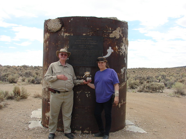
This was our eventual destination: Project Faultless, the site of a 1-megaton nuclear blast detonated almost a kilometer underground on January 19, 1968. This 2.25 m pipe was the top of the hole drilled to lower the bomb underground. Before the blast, the top of the pipe was level with the ground. The blast caused the ground to subside around 2.75 meters, leaving this bit protruding above ground level. The pipe was sealed with concrete.
Here was our route for the day. Ignore the label for the school district: it's an artifact of how I had to convince Google Maps to draw the route correctly.
The irony in calling this test "Faultless" was that the blast reactivated various inactive faults and was pretty much a complete failure. The reason for doing the test was to try and find a new location farther north of the Nevada Test Site (and thus farther away from Las Vegas) for doing progressively larger bomb tests, as the tests were rattling windows and nerves in Las Vegas. Had the test been successful, the government would have established a new test area around this site.

After the failure of this test, the government sealed everything up, put a plaque on the pipe, and folded the project.
Project Faultless is around 150 km east of Tonopah, and is not a trivial excursion. We topped off the gas tank in Tonopah and packed a lunch before setting off east across US-6, a highway that could easily challenge US-50 for the title of "Loneliest Road in America." We had researched the route in advance and printed out the directions from Google Maps, as there's obviously no cell phone reception where we were going.
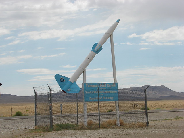
East of Tonopah Airport (the former Tonopah Army Air Force Base) is the turnoff to the Tonopah Test Range.

Continuing east, we came to the Saulsbury Wash Rest Area. We stopped briefly here, because while it is minimal (pit toilets only, no water), it's the last chance rest stop between here and where we were going. There's another "rest area" on the map adjacent to an NV DOT base, but it consists of a parking area, a tree, and a picnic table.
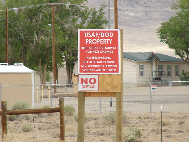
Beyond the NV-375 junction for the Extraterrestrial Highway is a location signed as "Base Camp." This was the base camp for the Faultless test, which was turned over to the US Air Force after the idea of setting up a Central Nevada Test Site was abandoned after the failure of Faultless. The Google Maps view of the site shows the runway here is marked as closed, but the site does appear to still be in use; however, we don't know exactly what it's used for.
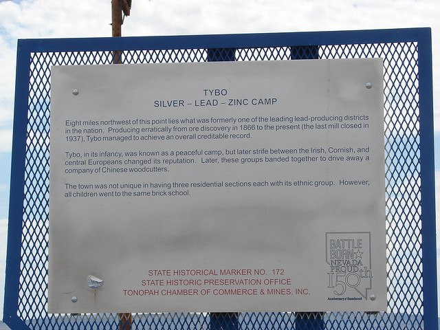

Across from Base Camp is a historical monument and informational signs about the Tybo mines north of here. The road through Base Camp that leads to Tybo is public, but the first mile is restricted due to the military station here.

Following the Google Maps directions, we turned at Hot Creek Road. It's good that we did not just go by the Google Streetview landmarks, because the lone tree surrounded by a fence that we saw online is gone.

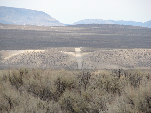
The road was a decent quality dirt-and-gravel road (good for about 25 mph without rattling the van too much), but as we turned onto other roads looking for our first site, the quality went down a bit. Indeed, we probably would not have made this trip if we hadn't had the tires replaced and replaced the mini-spare with a full-size tire recently.
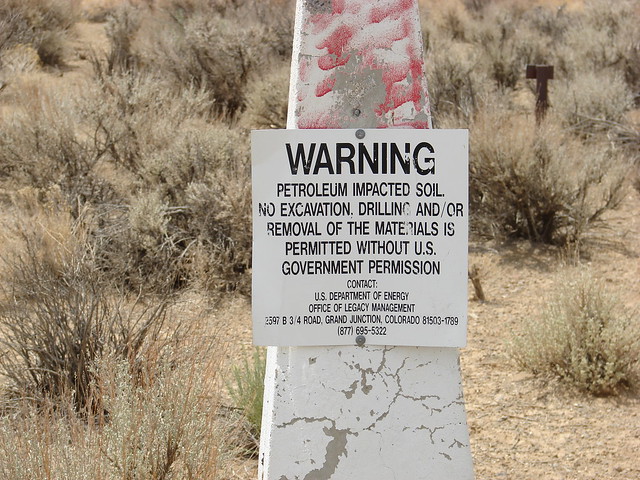
Each of the cones has this warning notice on it.

Our first stop here was what appears to be the site of Project Adagio, which would have been the next test in the series after Faultless. It was abandoned and sealed, with the test renamed and moved to Amchitka Island in Alaska.


There are various mysterious bits of remains at the site.
Also mysterious was how Google initially said that we should have been able to go straight from here to Faultless. However, all paths away from this site (except the road on which we came in) were distinctly sketchy. If we'd been on an ATV it probably would have been okay, but not in my minivan! We returned the way we came and turned toward Faultless.

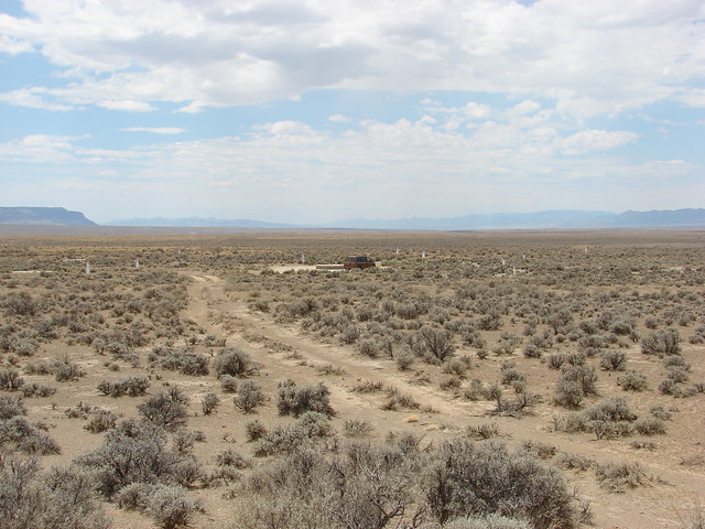
The mountains around this area are very striking, assuming you like basin-and-range geology.

As we neared the area where the map showed Faultless to be, we stopped periodically to try and find it, remembering how we overshot Project Shoal on our previous nuclear excursion.

The map showed we should be almost on top of it here when Lisa got out to look around, leaving me to keep the van running.

Driving another 50-100 meters, we found the small branch road to the site of the test itself.
After taking pictures, we ate our lunch. The weather was good, and pleasant after the heat we'd had at home last week. Intermittent clouds cut the sun, which was fine by us.
From the Faultless site, we realized that there was a better road that led back to US-6, so we returned to the main highway that way. It would have been quicker to come in this way, but Google Maps routed us the way we came, and without that we would have missed the Project Agadio site. Nothing around here is signposted, of course.
We went straight back to the Belvada with no additional stops, as we were getting a little worn out by then. After a bit of a rest, we went to Raley's again and bought another pizza. We have a kitchen, after all, and it was more relaxing after bouncing over back roads to take off our shoes, sit back, and have a pizza than to go back out for dinner.
This was a very interesting trip, and I'm glad we made it. This was Lisa's fifth atomic bomb site, and my fourth.
This was our eventual destination: Project Faultless, the site of a 1-megaton nuclear blast detonated almost a kilometer underground on January 19, 1968. This 2.25 m pipe was the top of the hole drilled to lower the bomb underground. Before the blast, the top of the pipe was level with the ground. The blast caused the ground to subside around 2.75 meters, leaving this bit protruding above ground level. The pipe was sealed with concrete.
Here was our route for the day. Ignore the label for the school district: it's an artifact of how I had to convince Google Maps to draw the route correctly.
The irony in calling this test "Faultless" was that the blast reactivated various inactive faults and was pretty much a complete failure. The reason for doing the test was to try and find a new location farther north of the Nevada Test Site (and thus farther away from Las Vegas) for doing progressively larger bomb tests, as the tests were rattling windows and nerves in Las Vegas. Had the test been successful, the government would have established a new test area around this site.
After the failure of this test, the government sealed everything up, put a plaque on the pipe, and folded the project.
Project Faultless is around 150 km east of Tonopah, and is not a trivial excursion. We topped off the gas tank in Tonopah and packed a lunch before setting off east across US-6, a highway that could easily challenge US-50 for the title of "Loneliest Road in America." We had researched the route in advance and printed out the directions from Google Maps, as there's obviously no cell phone reception where we were going.
East of Tonopah Airport (the former Tonopah Army Air Force Base) is the turnoff to the Tonopah Test Range.
Continuing east, we came to the Saulsbury Wash Rest Area. We stopped briefly here, because while it is minimal (pit toilets only, no water), it's the last chance rest stop between here and where we were going. There's another "rest area" on the map adjacent to an NV DOT base, but it consists of a parking area, a tree, and a picnic table.
Beyond the NV-375 junction for the Extraterrestrial Highway is a location signed as "Base Camp." This was the base camp for the Faultless test, which was turned over to the US Air Force after the idea of setting up a Central Nevada Test Site was abandoned after the failure of Faultless. The Google Maps view of the site shows the runway here is marked as closed, but the site does appear to still be in use; however, we don't know exactly what it's used for.
Across from Base Camp is a historical monument and informational signs about the Tybo mines north of here. The road through Base Camp that leads to Tybo is public, but the first mile is restricted due to the military station here.
Following the Google Maps directions, we turned at Hot Creek Road. It's good that we did not just go by the Google Streetview landmarks, because the lone tree surrounded by a fence that we saw online is gone.
The road was a decent quality dirt-and-gravel road (good for about 25 mph without rattling the van too much), but as we turned onto other roads looking for our first site, the quality went down a bit. Indeed, we probably would not have made this trip if we hadn't had the tires replaced and replaced the mini-spare with a full-size tire recently.
Each of the cones has this warning notice on it.
Our first stop here was what appears to be the site of Project Adagio, which would have been the next test in the series after Faultless. It was abandoned and sealed, with the test renamed and moved to Amchitka Island in Alaska.
There are various mysterious bits of remains at the site.
Also mysterious was how Google initially said that we should have been able to go straight from here to Faultless. However, all paths away from this site (except the road on which we came in) were distinctly sketchy. If we'd been on an ATV it probably would have been okay, but not in my minivan! We returned the way we came and turned toward Faultless.
The mountains around this area are very striking, assuming you like basin-and-range geology.
As we neared the area where the map showed Faultless to be, we stopped periodically to try and find it, remembering how we overshot Project Shoal on our previous nuclear excursion.
The map showed we should be almost on top of it here when Lisa got out to look around, leaving me to keep the van running.
Driving another 50-100 meters, we found the small branch road to the site of the test itself.
After taking pictures, we ate our lunch. The weather was good, and pleasant after the heat we'd had at home last week. Intermittent clouds cut the sun, which was fine by us.
From the Faultless site, we realized that there was a better road that led back to US-6, so we returned to the main highway that way. It would have been quicker to come in this way, but Google Maps routed us the way we came, and without that we would have missed the Project Agadio site. Nothing around here is signposted, of course.
We went straight back to the Belvada with no additional stops, as we were getting a little worn out by then. After a bit of a rest, we went to Raley's again and bought another pizza. We have a kitchen, after all, and it was more relaxing after bouncing over back roads to take off our shoes, sit back, and have a pizza than to go back out for dinner.
This was a very interesting trip, and I'm glad we made it. This was Lisa's fifth atomic bomb site, and my fourth.
no subject
Date: 2021-07-05 01:27 pm (UTC)US-6 comes through Omaha, just a couple blocks from where we live at that.
no subject
Date: 2021-07-05 02:28 pm (UTC)